UPDATED October 25th, 2019 — this is a dispatch from my cycle tour of Ukraine and surroundings this past Summer with my partner Nastia, an open project on an Autumn/Winter hiatus — check out the project page more information, and sign up for my newsletter if you would like to be notified when it resumes 🙂
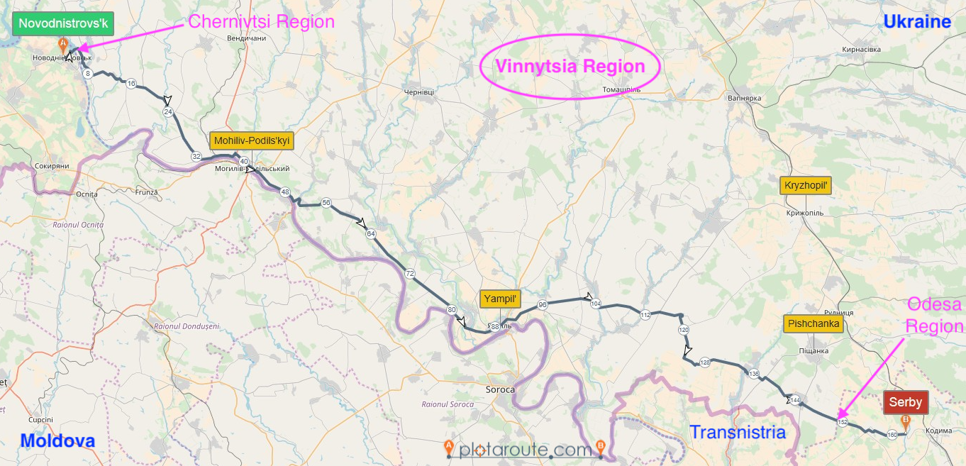
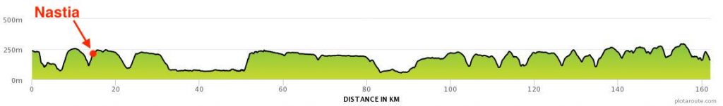
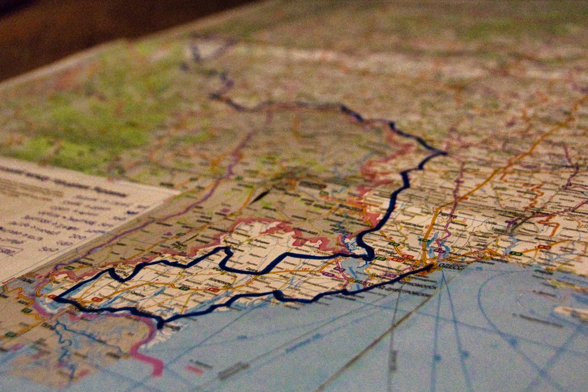
Shortly after leaving Novodnistrovs’k (Chernivtsi Region, Sokyriany district), we crossed the Dnister River at the Dnister Hydroelectric Power Station into the administrative region of Vinnytsia. We spent four gruesome days riding up and down the steep Podolian Uplands’ valleys along the River until inconspicuously passing into the Odesa Region via the village of Bashtankiv (Kodyma district).
A (not so) quick preamble
Leaving behind Chernivtsi and its bus stops, i started photographing the markers often found welcoming one’s arrival at a populated place — they’re sometimes monumental in the formerly Soviet world.
I noticed two during our first 24 hours in the region.
,")
.")
The first marker showed some promise, but the second one (and the absence of many others) disappointed.
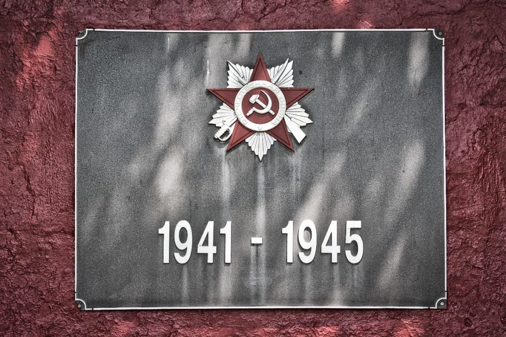
That’s when i spotted the first hammer and sickle i’d ever seen on public display in Ukraine! I put down the bicycle, got out my camera, and mobilized Nastia to read and translate it to me — the annotations were in Russian.
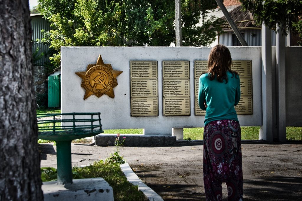
It turned out to be a war memorial — the Great Patriotic War (of 1941–45), as the elsewhere called Eastern Front of World War II was known in the Soviet Union and still is in some of its former territories.
Decommunization
I realize now that i had seen a couple of those memorials before — in Ivano-Frankivsk, we passed by the “eternal” flame of victory, which was off — the night before we had camped right next to the one in Khon’kivtsi, where the “red star” was notably white — if their Soviet overtones were ever more explicit, enough people didn’t like them that they’ve been removed, or at least unmaintained to their disintegration. Even Nastia was confused, noting that she should look into what had been this Great “National” War, as she first translated what was written on the monument where we now stood before the unmistakable Soviet symbol.
Wondering whether i might spot other instances of the symbol, i started documenting them as well, keeping the location markers as a backup.
From the toppling of (thousands of) statues of Lenin (Leninopad) to the renaming of (tens of thousands of) streets, communist references from the quintessential to the obscurest have been (sometimes forcefully) disappearing from the face of Ukraine since the country’s independence from the Soviet Union in 1991. The results of this process are most noticeable (or rather, unnoticeable) in the West, where i’ve spent most of my time in Ukraine so far. In 2015, the display of Soviet symbols in public spaces was rendered illegal the paradoxical and controversial Decommunization Laws:
- Law No. 2558: “On the condemnation of the communist and national socialist (Nazi) regimes, and prohibition of propaganda of their symbols”
- Law No. 2538-1: “On the legal status and honoring of fighters for Ukraine’s independence in the 20th century”
- Law No. 2539: “On remembering the victory over Nazism in the Second World War”
- Law No. 2540: “On access to the archives of repressive bodies of the communist totalitarian regime from 1917-1991”
Tourist and resident worlds collide
Here’s a bit of the paradox — my humble contribution as a mathematician (i didn’t know any of this when i took the photos). As a tourist, i usually make my best effort to stay away from politics — but Ukraine is now also where i live.
So, Law No. 2539 does away with Great Patriotic War, replacing it with World War II, (1939–45), “[a]ware that [it] (…) began as a result of the arrangements of the national-socialist (…) regime of Germany and the communist totalitarian regime of the USSR” (translation quoted from Nikolay Koposov; Memory Laws, Memory Wars, pp. 201–2).
On the other hand, Law No. 2558 (Article 3) exempts Great Patriotic War memorials — as i understand it, they’re allowed to preserve the denomination, dates, hammer and sickles, as well as any other Soviet references they were installed with.
I also said the laws are controversial — indeed several scholars and institutions (including the European Commission for Democracy through Law) have raised concerns that the laws are vague and susceptible to abuse that might curtail freedom of speech and association. If you’re interested, you may read more from historians, political scientists, graduate students, artists, and draw your own conclusions 🙂
Paradoxical or controversial, the laws are fascinating — they reflect a nation under hasty construction in real-time. I’m curious to see how these war monuments will be understood in the near future in light of the restrictions and historical stipulations mandated by the legislation — will Ukrainians feel encouraged to ask questions about their history? You might get different answers to this question depending on who you ask or which of the laws you read.
Anyway — legal and (still) relatively abundant, the memorials lost much of the appeal.
Back to plan A
This brought me back to the location markers — and eventually, as luck would have it, to a fairly monumental (and, as i understand, already illegal) hammer and sickle that hasn’t yet been removed!
I hope you’ll enjoy this brief photo essay. As before, i’ve laid the story out so the narrative develops linearly from the main text to image captions, then back to the text, and so on — to read the captions, just click on the first image, then flip through them 😉
Location Markers from Vinnytsia
As with the bus stops from Chernivtsi, it made the most sense to tell this story district by district. By the way, whether or not you have noticed or care at all, that’s the word in English i’ve adopted for raion (район), the next layer of administrative divisions in Ukraine below the Region — in turn, the translation i’ve followed for Oblast’ (Область).
We passed by four districts — Mohiliv-Podil’s’kyi, Yampil’, Kryzhopil’ and Pishchanka.
Mohiliv-Podil’s’kyi district
 --- that is, if you could find it ;-)")
,")

")
")
")
As i hinted above, the location markers in this district were the least eventful — where they’re still the responsibility of the district administration, they don’t seem to be maintained — where they’re under the auspices of the (newly established) local governments, keeping up with Soviet extravagance doesn’t seem to be a priority.
This is partially reflected on the border with the district of Yampil’:
 from the relief where the letters used to be.")

Yampil’ district
The settlement entrances in this district were the most fun to photograph. They were each unique, but all followed a Cossack theme. A few of the location markers were sculpted in stone — reflexes of the area’s history and tradition [1, 2].
")

")
")


")

Kryzhopil’ district
If the next district border or the first settlement in it (Shumy) were marked in any way, i didn’t notice it — possibly because i was too focused on the steep downhill after Dovzhok? That’s where OpenStreetMap tells me the imaginary line must have been crossed.
Up yet another arduous slope, the next marker was impossible to miss though — it reveals itself gradually and momentously as you suffer the last pedal strokes of the climb from Shumy, ominously announcing its end letter by letter, and the next photo shooting break — В — І — Л — Ь — Ш — Н — К — А
I’m exhausted, where can i lean my bicycle? I’m looking up now — is that a hammer and sickle?
It is, and that’s not a war memorial — i don’t know why this makes me so excited, but it does.
")
")
It probably cost a lot to build it, and it will likely cost another bunch to go up there and remove the symbol — what will it be replaced with?
This climatic marker was the only we saw in our brief swing in and out of the Kryzhopil’ district.
Pishchanka district
I don’t have anything else to say — shortly after Vil’shanka, we were already crossing into the fourth and final district, where this exercise cooled down and wrapped up with the last two exemplars i noticed.


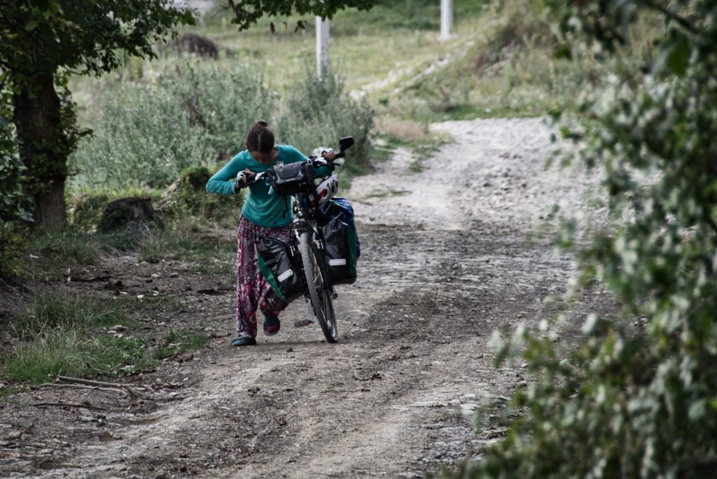
In the second one, i also made an attempt to capture what has been a reliable feature of Ukrainian countryside so far — dirt roads in parallel (and often preferred) to the old asphalt ones. I shot a video wondering about that on my 2017 cycle tour. We found out from the locals that these solutions emerge spontaneously — “Who builds these roads?” — “Nobody builds them, people simply start driving off-road to avoid the crumbling asphalt, and it eventually becomes a road” — go self-determination!
“Rule 1: Find a place you trust and then try trusting it for a while.”
“10 Rules for Students and Teachers” by Sister Corita Kent (and John Cage)
Once again, i could have done more — one could have taken better photos, or gone a lot deeper into these markers — pieces of information, relics from the past, reflexes of power structures, expressions of identity and pride, objects of art, historical accounts of aesthetic preferences and local traditions — the list goes on.
This is only the second essay in this meta practice to notice and record a superficial feature of each administrative region of Ukraine we visit on our tour, and i’m already beginning to feel that it will eventually be my duty to handle at least one of them more thoroughly.
A reader pointed out that this has been done by photographer Christopher Herwig with the bus stops, although he seems to have approached them from their architecture and design.
Disappearing Soviet symbols in Ukraine have also been tackled in Looking for Lenin, by photographer Niels Ackermann and journalist Sébastien Golbert, who went on a quest to find out what happened to some of those statues after their removal.
There doesn’t seem to be much yet on Soviet location markers 😀
Not now though — and i won’t mind if someone else in a better position does it. For the moment, i’ve consciously chosen to carry out this project at this scale — one that i find compatible with my broad interests and current skills, not to mention my time frame and budget — perhaps most importantly, because i’m enjoying the play 🙂
I hope you’re enjoying it also, and please keep the feedback coming — i’ll be back soon with what i did in Odesa <3
___
Featured photo: outline of our route through the administrative region of Vinnytsia (courtesy of plotaroute.com and © OpenStreetMap contributors)
Sign up for my newsletter and receive long-term travel
inspiration & advice delivered weekly, straight into your inbox
")
")
, this was a Ukrainian Orthodox Church service held in Moldovan and Russian (Krutoyarivka, Bilhorod-Dnistrovs'kyi District, Odesa Region, Ukraine, Summer '19)")
")
 in 2011, together with the Cossack sculptures frequently found (and dated) near them (Yampil District, Vinnytsia Region, Ukraine, Summer '19)")
")